The sequence
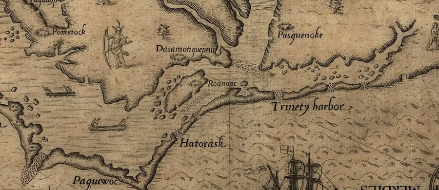
In 1587 John White led a group of about 115 settlers to Roanoke Island, off what is now North Carolina. White sailed back to England for supplies and was unable to return for three years — England was at war with Spain, and every ship was needed against the Armada.
When he finally reached Roanoke in August 1590, the settlement was dismantled. The houses had been taken apart, not destroyed. On a post was carved the word CROATOAN; on a nearby tree, CRO. White had agreed with the colonists that if they moved they would carve the name of their destination, and that if they were in danger they would carve a cross. There was no cross.
White wanted to search Croatoan Island (modern Hatteras) immediately. Bad weather and a damaged ship forced the expedition back to England, and he never returned.
The evidence for assimilation
- The settlement was taken down carefully. That indicates a planned move, not a massacre or a panicked flight.
- The destination was named. Croatoan was the island of the Croatoan people, whose leader Manteo had travelled to England and was an ally.
- Later reports. English expeditions in the 1600s were told by local peoples of Europeans living inland, and of people with blue eyes and grey eyes among the Tuscarora and other groups. These are second-hand, but they are consistent.
- The map. In 2012 researchers at the British Museum found a patch on White's 1590 map concealing a symbol for a fort, further inland at the head of Albemarle Sound, in an area the colonists had discussed moving to. Excavations at that site ("Site X") have produced late-sixteenth-century English and Native artefacts together.
Nobody has proved the colonists' fate in detail, and the "Site X" work is suggestive rather than conclusive. The honest position is that a planned relocation toward the Croatoan, followed by absorption into local communities over years, fits every piece of evidence — the dismantled houses, the carved destination, the absence of a danger sign, and the later reports.
The "vanished colony" is a later framing, and it required ignoring the colonists' own message. Compare lost continents: a real place, renamed by people who were not there.
Why the story became supernatural
Because a disappearance is a better story than a merger. Roanoke entered American folklore as an eerie blank, and the blanks attract explanations — pirates, Spanish raiders, a storm, disease, the "lost" tribe. Some are possible; none is needed to explain what the colonists themselves wrote down.
The lesson is one this archive keeps returning to: the primary source usually answers the question, and it is usually less exciting than the legend.
Sources for this page
- Wikipedia, “Roanoke Colony” — timeline, CROATOAN, later reportsen.wikipedia.org
- British Museum, “The Roanoke colony map” — the concealed fortbritishmuseum.org
- First Colony Foundation — Site X excavationsfirstcolonyfoundation.org